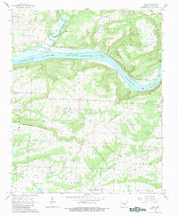
1965 Map of Cecil
USGS Topo · Published 1983About this map
Arkansas River navigation and local extraction define the landscape of Franklin County in the mid-1960s. The creation of Ozark Lake is a central feature of this era, with the survey noting blue-hatched areas destined for submergence by the new reservoir. Along the northern banks, the Missouri Pacific railroad follows the river's curve, passing the small settlement of Poping.
Find a feature on this map
41 named features on this map. Tap any name to fly to it.
Don’t see what you’re looking for? This feature index may not catch every label — zoom into the map to look around manually.
Map Details
Editions of this 1965 Cecil Map
2 editions found
Other maps of this area

1879 · Cravens
USGS Topo · 1:62,500

1887 · Magazine Mountain #2
USGS Topo · 1:62,500

1887 · Watalula
USGS Topo · 1:62,500

1887 · Magazine Mountain
USGS Topo · 1:62,500

1890 · Magazine Mountain
USGS Topo · 1:125,000

1890 · Fort Smith
USGS Topo · 1:125,000

1898 · Winslow #4
USGS Topo · 1:62,500

1898 · Winslow
USGS Topo · 1:125,000

1901 · Winslow
USGS Topo · 1:125,000

1906 · Lavaca
USGS Topo · 1:62,500