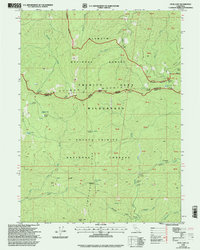
1998 Map of Cecil Lake
USGS Topo · Published 2003About this map
The Trinity Alps dominate this high-elevation landscape where the Salmon-Trinity Alps Wilderness and several national forests converge. The terrain is marked by remote backcountry shelters and historic pack-trail points such as Fosters Cabin, Jorstad Cabin, and Morrison Cabin. Water features define the drainage patterns, including Cecil Lake below Cecil Point and the headwaters of the North Fork Trinity River. The map captures a moment in the late 1990s when remote recreation sites like China Gardens Campsite and Pegleg Campsite supported travelers through the high passes. Land management is complex here, with the Wilderness Boundary weaving through steep ridges like Limestone Ridge, illustrating the transition from managed timberlands in the Shasta-Trinity National Forests to protected wilderness.
Find a feature on this map
42 named features on this map. Tap any name to fly to it.
Don’t see what you’re looking for? This feature index may not catch every label — zoom into the map to look around manually.
Map Details
Editions of this 1998 Cecil Lake Map
This is the sole edition of this map. No revisions or reprints were ever made.
Other maps of this area

1909 · Big Bar
USGS Topo · 1:96,000

1915 · Big Bar and Vicinity
USGS Topo · 1:250,000

1948 · Weed
USGS Topo · 1:250,000

1950 · Weed
USGS Topo · 1:250,000

1951 · Helena
USGS Topo · 1:62,500

1951 · Ironside Mountain
USGS Topo · 1:62,500

1955 · Salmon Mtn
USGS Topo · 1:62,500

1955 · Cecilville
USGS Topo · 1:62,500

1958 · Redding
USGS Topo · 1:250,000

1958 · Weed
USGS Topo · 1:250,000