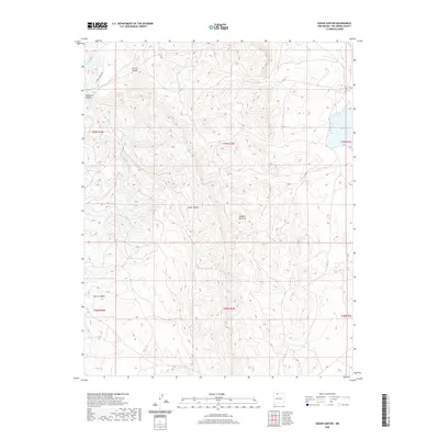
2020 Map of Cedar Canyon
USGS Topo · Published 2020About this map
Cedar Canyon and its network of high-desert drainage systems define this section of Rio Arriba County, where the topography transitions between mesas and deep incisions. In the northeastern corner, Stone Lake provides a significant water source within the arid landscape, while smaller features like Dipping Vat Tank and Cedar Spring indicate the essential points of contact for ranching and wildlife in the high country. The map illustrates a landscape shaped by seasonal water flow, with La Jara Cr and its associated La Jara Canyon cutting through the northwestern reaches. This 2020 edition captures the modern landscape of the Public Land Survey System, showing the established sections and township lines that organize these remote canyons, including the namesake Cedar Canyon and the neighboring Telephone Canyon and Burro Canyon.
Find a feature on this map
14 named features on this map. Tap any name to fly to it.
Don’t see what you’re looking for? This feature index may not catch every label — zoom into the map to look around manually.
Map Details
Editions of this 2020 Cedar Canyon Map
This is the sole edition of this map. No revisions or reprints were ever made.
Other maps of this area
1889 · Largo
USGS Topo · 1:250,000
1895 · Largo
USGS Topo · 1:250,000
1954 · Aztec
USGS Topo · 1:250,000
1955 · Lumberton
USGS Topo · 1:62,500
1955 · Boulder Lake
USGS Topo · 1:62,500
1958 · Aztec
USGS Topo · 1:250,000
1962 · Aztec
USGS Topo · 1:250,000
1963 · Cement Lake
USGS Topo · 1:24,000
1963 · John Mills Lake
USGS Topo · 1:24,000
1963 · Leavry Canyon
USGS Topo · 1:24,000