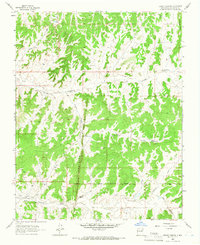
1963 Map of Leavry Canyon
USGS Topo · Published 1966About this map
The Jicarilla Apache Indian Reservation dominates the southern landscape of this mid-1960s survey, defined by the Jicarilla Apache Indian Reservation Boundary. The terrain is shaped by the presence of the Continental Divide cutting through the northeast corner, influencing the drainage patterns of Tapicito Creek and the deep seasonal channels of Arroyo Compañero. Natural and man-made water sources are vital in this high-desert environment, including Bassett Spring, Garambulla Well, and Red Lake. Evidence of mid-century industrial activity is scattered across the township lines in the form of several Gas Well and Drill Hole sites. The central geography is marked by the prominent Tapicito Ridge and the Leavry Canyon system, which contains both the Lower Leavry Pond and Upper Leavry Pond, highlighting the area's complex water management and natural topography during this era of resource exploration.
Find a feature on this map
19 named features on this map. Tap any name to fly to it.
Don’t see what you’re looking for? This feature index may not catch every label — zoom into the map to look around manually.
Map Details
Editions of this 1963 Leavry Canyon Map
2 editions found
Other maps of this area

1889 · Largo
USGS Topo · 1:250,000

1895 · Largo
USGS Topo · 1:250,000

1909 · Gallina
USGS Topo · 1:125,000

1954 · Aztec
USGS Topo · 1:250,000

1955 · Llaves
USGS Topo · 1:62,500

1955 · Boulder Lake
USGS Topo · 1:62,500

1958 · Aztec
USGS Topo · 1:250,000

1962 · Aztec
USGS Topo · 1:250,000

1963 · Schmitz Ranch
USGS Topo · 1:24,000
1963 · Ojito
USGS Topo · 1:24,000