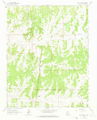
1963 Map of Leavry Canyon
USGS Topo · Published 1975About this map
The Continental Divide winds through the high country of Rio Arriba County in the early 1960s, marking the hydrological crest of this arid landscape. This survey reveals an active Gas Field development, with numerous Gas Wells and several Drill Holes scattered across the complex terrain. The southern portion of the map is defined by the Jicarilla Apache Indian Reservation Boundary, separating tribal lands from the surrounding public and private domain. Water sources are critical landmarks in this environment, including Bassett Spring, Garambulla Well, and small catchments like Lower Leavry Pond and Upper Leavry Pond. Distinctive geographic features such as Tapicito Ridge and the deep cuts of Leavry Canyon and Bear Canyon structure the drainage patterns for Tapicito Creek and Chico Creek.
Find a feature on this map
17 named features on this map. Tap any name to fly to it.
Don’t see what you’re looking for? This feature index may not catch every label — zoom into the map to look around manually.
Map Details
Editions of this 1963 Leavry Canyon Map
2 editions found
Other maps of this area

1889 · Largo
USGS Topo · 1:250,000

1895 · Largo
USGS Topo · 1:250,000

1909 · Gallina
USGS Topo · 1:125,000

1954 · Aztec
USGS Topo · 1:250,000

1955 · Llaves
USGS Topo · 1:62,500

1955 · Boulder Lake
USGS Topo · 1:62,500

1958 · Aztec
USGS Topo · 1:250,000

1962 · Aztec
USGS Topo · 1:250,000

1963 · Schmitz Ranch
USGS Topo · 1:24,000
1963 · Ojito
USGS Topo · 1:24,000