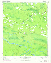
1942 Map of Cedar Creek
USGS Topo · Published 1976About this map
The Santee River and the vast Santee Swamp dominate this lowcountry landscape on the border of Georgetown and Berkeley counties. The map captures a transition period in the mid-20th century, where the timber and agricultural lands of the Francis Marion National Forest meet the watery reaches of Wadmacon Island and Wadmacon Creek. Settlement is concentrated along the Seaboard Coast Line railroad, notably at Lambert, while river-dependent sites like Price Landing and Guilliard Lake hint at an older economy tied to the river's flow and the natural cutoff channels.
Find a feature on this map
33 named features on this map. Tap any name to fly to it.
Don’t see what you’re looking for? This feature index may not catch every label — zoom into the map to look around manually.
Map Details
Editions of this 1942 Cedar Creek Map
2 editions found
Other maps of this area

1942 · Cedar Creek
USGS Topo · 1:24,000

1942 · Honey Hill
USGS Topo · 1:24,000

1943 · Olin
USGS Topo · 1:31,680

1943 · Shulerville
USGS Topo · 1:24,000

1943 · Trio
USGS Topo · 1:24,000

1943 · Kilsock Bay
USGS Topo · 1:24,000

1943 · Andrews
USGS Topo · 1:24,000

1943 · Jamestown
USGS Topo · 1:24,000

1943 · Santee
USGS Topo · 1:24,000

1949 · Georgetown
USGS Topo · 1:250,000