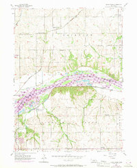
1956 Map of Cedar Creek
USGS Topo · Published 1970About this map
The Platte River serves as the dominant boundary between Sarpy and Cass counties, defining a landscape of active river dynamics and agricultural settlement. The 1956 survey, updated with 1969 aerial revisions, reveals a dense network of rural infrastructure, including numerous schoolhouses like Sarpy Center Sch, Bell Sch, and Cullom Sch. These small district schools, along with sites like the Lutheran Ch and Glendale Cem, indicate a well-established farming community organized around the river valley.
Find a feature on this map
29 named features on this map. Tap any name to fly to it.
Don’t see what you’re looking for? This feature index may not catch every label — zoom into the map to look around manually.
Map Details
Editions of this 1956 Cedar Creek Map
5 editions found

Other maps of this area

1893 · Fremont
USGS Topo · 1:125,000

1896 · Fremont
USGS Topo · 1:125,000

1903 · Weeping Water
USGS Topo · 1:125,000

1929 · Weeping Water
USGS Topo · 1:125,000

1935 · Nehawka
USGS Topo · 1:48,000

1940 · Nehawka
USGS Topo · 1:62,500

1954 · Omaha
USGS Topo · 1:250,000

1955 · Fremont
USGS Topo · 1:250,000

1955 · Nebraska City
USGS Topo · 1:250,000

1955 · Lincoln
USGS Topo · 1:250,000