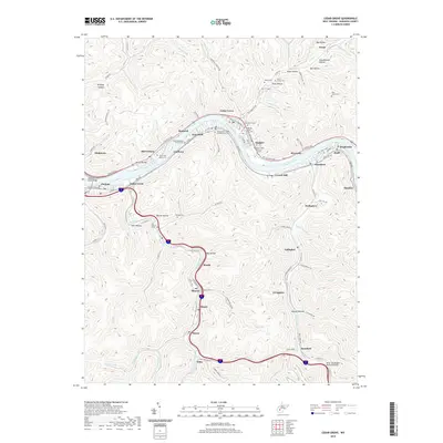
2019 Map of Cedar Grove
USGS Topo · Published 2019About this map
The Kanawha River carves a deep valley through the center of this terrain, anchoring a dense string of riverside settlements from Chelyan and East Bank to Cedar Grove and Pratt. This late 2010s survey shows a landscape where industrial infrastructure and local heritage intersect, particularly visible in the numerous cemeteries that dot the hillsides. Of particular historical significance is the Virginias Chapel Slave Cem near Glasgow, alongside other family and fraternal sites like the Lacie-Gray-Morris Cem and the Independent Order of Oddfellows Cem. Moving south away from the main river, a network of hollows—including Mill Hollow and Whites Hollow—guides the development of smaller communities like Sharon, Miami, and Dawes along the winding course of Cabin Creek. The map also details modern crossings such as the Admiral T J Lopez Bridge, reflecting the ongoing importance of the river corridor for regional connectivity.
Find a feature on this map
104 named features on this map. Tap any name to fly to it.
Don’t see what you’re looking for? This feature index may not catch every label — zoom into the map to look around manually.
Map Details
Editions of this 2019 Cedar Grove Map
This is the sole edition of this map. No revisions or reprints were ever made.
Other maps of this area

1897 · Kanawha Falls
USGS Topo · 1:125,000

1899 · Charleston
USGS Topo · 1:125,000

1900 · Kanawha Falls
USGS Topo · 1:125,000

1901 · Kanawha Falls
USGS Topo · 1:125,000

1907 · Clendenin
USGS Topo · 1:62,500

1908 · Montgomery
USGS Topo · 1:48,000

1909 · Charleston
USGS Topo · 1:62,500

1909 · Clendenin
USGS Topo · 1:62,500

1909 · Peytona
USGS Topo · 1:48,000

1910 · Montgomery
USGS Topo · 1:62,500