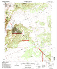
1994 Map of Cedar Hill
USGS Topo · Published 1997About this map
Cedar Hill dominates the high desert terrain of the California-Nevada border, overlooking the vast expanse of Alkali Valley and Mono Valley. This 1994 revision, based on surveys from the early 1980s, captures a landscape defined by state and county political lines, including the historic Von Schmidt Boundary. This specific survey line was a 19th-century attempt to demarcate the Nevada California Boundary, leaving a physical record of legal disputes over the desert frontier.
Find a feature on this map
16 named features on this map. Tap any name to fly to it.
Don’t see what you’re looking for? This feature index may not catch every label — zoom into the map to look around manually.
Map Details
Editions of this 1994 Cedar Hill Map
2 editions found
Other maps of this area

1909 · Hawthorne
USGS Topo · 1:250,000

1911 · Hawthorne
USGS Topo · 1:250,000

1915 · Hawthorne
USGS Topo · 1:250,000

1948 · Walker Lake
USGS Topo · 1:250,000

1955 · Powell Mtn
USGS Topo · 1:62,500

1956 · Aurora
USGS Topo · 1:62,500

1957 · Walker Lake
USGS Topo · 1:250,000

1958 · Trench Canyon
USGS Topo · 1:62,500

1958 · Huntoon Valley
USGS Topo · 1:62,500

1962 · Walker Lake
USGS Topo · 1:250,000