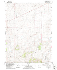
1986 Map of Cedar Knob
USGS Topo · Published 1986About this map
Cedar Knob stands as a prominent landmark in this high-altitude landscape of northwest Colorado, surrounded by a complex system of seasonal drainages and ridges. The terrain is characterized by deep erosional features like Lone Tree Gulch, Thornburg Draw, and Jacobs Draw which flow through the arid basins toward the south and east. Mapping conducted in the early 1980s reveals a region primarily utilized for resource extraction and ranching, evidenced by the scattered Oil Well sites, a network of pipelines, and designated Drill Hole locations.
Find a feature on this map
21 named features on this map. Tap any name to fly to it.
Don’t see what you’re looking for? This feature index may not catch every label — zoom into the map to look around manually.
Map Details
Editions of this 1986 Cedar Knob Map
This is the sole edition of this map. No revisions or reprints were ever made.
Other maps of this area

1907 · White River
USGS Topo · 1:125,000

1910 · White River
USGS Topo · 1:125,000

1954 · Vernal
USGS Topo · 1:250,000

1958 · Vernal
USGS Topo · 1:250,000

1958 · Maybell
USGS Topo · 1:62,500

1958 · Citadel Plateau
USGS Topo · 1:62,500

1960 · Vernal
USGS Topo · 1:250,000

1960 · Elk Springs
USGS Topo · 1:62,500

1960 · Lone Mountain
USGS Topo · 1:62,500
1979 · Rangely
USGS Topo · 1:100,000