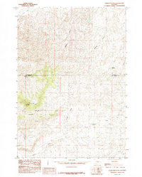
1985 Map of Cedar Mountain
USGS Topo · Published 1985About this map
Cedar Mountain dominates the western portion of this high-plains landscape, where the boundary between Washakie and Hot Springs counties cuts across a complex system of drainage channels. Collected from aerial photography in the late 1970s, this record reveals a terrain shaped by erosion, characterized by numerous ephemeral watercourses such as Walters Draw, Freeman Draw, and Sand Draw. The land is relatively open, with Tie Down Flats stretching across the northwestern corner. The presence of Mc Cee Reservoir in the northeast suggests localized water management in an otherwise arid environment defined by named gullies and draws like Wildcat Gulch and Neiber Draw. The naming conventions, including Coal Draw, hint at the geological and historical resource potential of this specific Wyoming quadrangle during the mid-1980s.
Find a feature on this map
11 named features on this map. Tap any name to fly to it.
Don’t see what you’re looking for? This feature index may not catch every label — zoom into the map to look around manually.
Map Details
Editions of this 1985 Cedar Mountain Map
This is the sole edition of this map. No revisions or reprints were ever made.
Other maps of this area

1945 · Kirby
USGS Topo · 1:62,500

1946 · Kirby
USGS Topo · 1:62,500

1955 · Thermopolis
USGS Topo · 1:250,000

1955 · Arminto
USGS Topo · 1:250,000

1958 · Thermopolis
USGS Topo · 1:250,000

1958 · Arminto
USGS Topo · 1:250,000

1960 · Coyote Hill
USGS Topo · 1:24,000

1960 · Red Hole
USGS Topo · 1:24,000

1960 · Thermopolis
USGS Topo · 1:24,000

1962 · Thermopolis
USGS Topo · 1:250,000