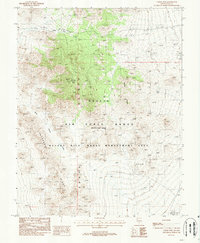
1988 Map of Cedar Pass
USGS Topo · Published 1988About this map
Kawich Range peaks dominate this high-desert landscape in Nye County, Nevada, where the high-altitude terrain of the Nellis Air Force Range intersects with the Nevada Wild Horse Management Area. This survey, compiled from early 1980s photography, documents a transition zone between military activity and wildlife preservation. The central ridge system includes prominent landmarks such as Cedar Peak and its namesake Tower, while the surrounding slopes are etched by drainages like Wild Horse Draw. Evidence of historical exploration and small-scale prospecting appears in the eastern foothills near Cedar Wells, where Mine Shafts are noted alongside the steep incline of White Ridge. Essential water sources, including Rose Spring, are mapped in an area otherwise defined by its arid, mountainous character, stretching toward the southern extent of Cathedral Ridge and Cedar Pass.
Find a feature on this map
14 named features on this map. Tap any name to fly to it.
Don’t see what you’re looking for? This feature index may not catch every label — zoom into the map to look around manually.
Map Details
Editions of this 1988 Cedar Pass Map
This is the sole edition of this map. No revisions or reprints were ever made.
Other maps of this area

1908 · Kawich
USGS Topo · 1:250,000

1942 · Reveille Peak
USGS Topo · 1:125,000

1952 · Kawich Peak
USGS Topo · 1:62,500

1952 · Quartzite Mtn
USGS Topo · 1:62,500

1952 · Reveille Peak
USGS Topo · 1:62,500

1952 · Belted Peak
USGS Topo · 1:62,500

1954 · Goldfield
USGS Topo · 1:250,000

1955 · Goldfield
USGS Topo · 1:250,000

1958 · Goldfield
USGS Topo · 1:250,000

1962 · Goldfield
USGS Topo · 1:250,000