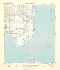
1941 Map of Cedar Point
USGS Topo · Published 1959About this map
Mon Louis Island dominates the central coastline of this 1940s survey, defined by the winding course of the Fowl River and its numerous coastal bayous. The map captures a transitional moment for the region's infrastructure, notably showing the G M and O (Abandoned) railroad line stretching toward the fishing community of Bayou La Batre. This coastal landscape is a complex network of marshes and water passages, where Grants Pass and Pass aux Herons provide critical navigation between Mobile Bay and the Mississippi Sound. Small settlements and landmarks like Alabama Port, Dixon Corner, and the Mobile Bay LH (lighthouse) anchor the shoreline. To the south, Dauphin Island is shown with its interior waters including Dauphin Island Bay and Graveline Bay, illustrating the area's intricate maritime geography before significant modern development altered these barrier island and mainland reaches.
Find a feature on this map
60 named features on this map. Tap any name to fly to it.
Don’t see what you’re looking for? This feature index may not catch every label — zoom into the map to look around manually.
Map Details
Editions of this 1941 Cedar Point Map
2 editions found

Other maps of this area

1921 · Grand Bay
USGS Topo · 1:62,500

1921 · Petit Bois Island
USGS Topo · 1:62,500

1921 · Point Clear
USGS Topo · 1:62,500

1921 · Fairhope
USGS Topo · 1:62,500

1921 · Dauphin Island
USGS Topo · 1:62,500

1921 · Delchamps
USGS Topo · 1:62,500

1922 · Mobile
USGS Topo · 1:62,500

1939 · Daphne
USGS Topo · 1:31,680

1940 · Hollingers Island
USGS Topo · 1:31,680

1940 · Mobile
USGS Topo · 1:62,500