
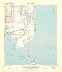
1941 Map of Cedar Point
USGS Topo · Published 1941About this map
Mon Louis Island and the marshy coast of Mobile County define this 1941 survey, showing a landscape of small maritime settlements and intricate tidal bayous. The fishing village of Bayou La Batre is a primary hub, while the G M and O railroad connects coastal outposts like Coden and Delchamps. The map captures the shoreline before the significant development of the late 20th century, marking navigation aids like the Mobile Bay Lh and the narrow passage at Cedar Point. To the south, Dauphin Island stretches along the Mississippi Sound, with several named bayous such as Bayou Aloe and Graveline Bay providing natural shelter. The abundance of named points, including Barron Point and Pt Judith, alongside numerous smaller waterways like East Fowl River and Austin Bayou, reflects the deep integration of water-based transport and industry in this era of Alabama's gulf coast history.
Find a feature on this map
63 named features on this map. Tap any name to fly to it.
Don’t see what you’re looking for? This feature index may not catch every label — zoom into the map to look around manually.
Map Details
Editions of this 1941 Cedar Point Map
2 editions found
Other maps of this area

1921 · Grand Bay
USGS Topo · 1:62,500

1921 · Petit Bois Island
USGS Topo · 1:62,500

1921 · Point Clear
USGS Topo · 1:62,500

1921 · Fairhope
USGS Topo · 1:62,500

1921 · Dauphin Island
USGS Topo · 1:62,500

1921 · Delchamps
USGS Topo · 1:62,500

1922 · Mobile
USGS Topo · 1:62,500

1939 · Daphne
USGS Topo · 1:31,680

1940 · Hollingers Island
USGS Topo · 1:31,680

1940 · Mobile
USGS Topo · 1:62,500