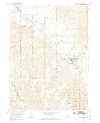
1954 Map of Cedar Rapids
USGS Topo · Published 1978About this map
The Cedar River valley in Boone County serves as the central artery for this mid-century portrait of East Central Nebraska. The agricultural landscape is defined by the diagonal transit of the Union Pacific railroad, which links the primary settlements of Cedar Rapids and Primrose. Significant revisions from the 1970s, shown in purple, document shifts in the river's channel and the evolution of local infrastructure since the original 1954 field check.
Find a feature on this map
17 named features on this map. Tap any name to fly to it.
Don’t see what you’re looking for? This feature index may not catch every label — zoom into the map to look around manually.
Map Details
Editions of this 1954 Cedar Rapids Map
Other maps of this area

1899 · St. Paul
USGS Topo · 1:125,000

1954 · Cedar Rapids
USGS Topo · 1:24,000

1954 · Spalding
USGS Topo · 1:24,000

1954 · Akron
USGS Topo · 1:24,000

1954 · Wolbach NE
USGS Topo · 1:24,000

1954 · Albion West
USGS Topo · 1:24,000

1954 · Belgrade
USGS Topo · 1:24,000

1954 · Belgrade NW
USGS Topo · 1:24,000

1954 · Cedar Rapids SE
USGS Topo · 1:24,000

1954 · Spalding SE
USGS Topo · 1:24,000