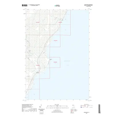
2019 Map of Cedar River
USGS Topo · Published 2019About this map
Cedar River serves as the focal point for this Menominee County coastal area, where the river meets the waters of Green Bay and Lake Michigan. This 2019 survey captures the settlement of Cedar River at the intersection of Cedar River Rd and Highway 35, showing the proximity of the Cedar River Cem to the winding riverbanks. The landscape is defined by its low-lying hydrology, with Elwood Cr and Deer Creek feeding into the larger river system through densely mapped wetlands. North along the coastline, the small settlement of Fox sits near the mouth of Deer Cr, marking a quiet stretch of the Upper Peninsula shore. The inclusion of localized road names like Dunkas Rd and Old Mill Lane No 20.75 provides specific navigational details for those researching contemporary land use and property access near Deadmans Point.
Find a feature on this map
22 named features on this map. Tap any name to fly to it.
Don’t see what you’re looking for? This feature index may not catch every label — zoom into the map to look around manually.
Map Details
Editions of this 2019 Cedar River Map
This is the sole edition of this map. No revisions or reprints were ever made.
Other maps of this area

1954 · Escanaba
USGS Topo · 1:250,000

1957 · Escanaba
USGS Topo · 1:250,000

1958 · Escanaba
USGS Topo · 1:250,000

1958 · Escanaba
USGS Topo · 1:62,500

1960 · Ellison Bay
USGS Topo · 1:62,500

1963 · Bark River
USGS Topo · 1:62,500

1963 · Cedar River
USGS Topo · 1:62,500

1981 · Marinette
USGS Topo · 1:100,000

1982 · Escanaba
USGS Topo · 1:100,000
1985 · Henderson Lakes
USGS Topo · 1:24,000