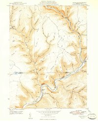
1948 Map of Cedar Run
USGS Topo · Published 1948About this map
Pine Creek dominates this 1940s landscape, carving through the steep topography of the Morris Gorge and the Gorge further south. The settlement of Cedar Run sits at the creek's confluence, served by the Cedar Run Ch and the Central New York railroad line that snakes along the water's edge. Further north, the remote community of Leetonia remains situated along the upper reaches of Cedar Run. The terrain is characterized by deeply incised hollows and hills named for local figures or geography, such as Callahan Hill and Gleason Hill. Along the eastern edge of the gorge, a Stone Quarry and the Blackwell Lloyd PO at Blackwell mark the small industrial and postal footprints in this heavily forested region of the Tioga and Lycoming county line.
Find a feature on this map
79 named features on this map. Tap any name to fly to it.
Don’t see what you’re looking for? This feature index may not catch every label — zoom into the map to look around manually.
Map Details
Editions of this 1948 Cedar Run Map
2 editions found
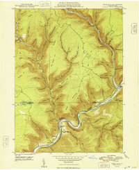
Other maps of this area

1937 · Waterville
USGS Topo · 1:48,000

1943 · Hyner
USGS Topo · 1:62,500

1943 · Waterville
USGS Topo · 1:62,500

1946 · Tiadaghton
USGS Topo · 1:24,000

1946 · Antrim
USGS Topo · 1:62,500

1946 · Renovo East
USGS Topo · 1:62,500

1946 · Cedar Run
USGS Topo · 1:24,000

1946 · Slate Run
USGS Topo · 1:24,000

1946 · Antrim
USGS Topo · 1:24,000

1946 · Morris
USGS Topo · 1:24,000
Featured Places
- Morris Township, PA
- Brown Township, PA
- Cedar Run, Brown Township
- Elk Township, PA
- Cedar Pines, Brown Township