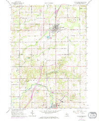
1967 Map of Cedar Springs
USGS Topo · Published 1973About this map
Cedar Springs serves as the central hub of this northern Kent County landscape, where the Penn Central rail line intersects a grid of numbered roads including 17 Mile Road and 18 Mile Road. To the south, the settlement of Rockford sits along the winding course of the Rogue River, an area marked by topographical shifts near Porter Hollow and Steaman Hollow. The map reveals a post-war rural environment in transition, as traditional agriculture and small crossroads like Solon Center and Edgerton exist alongside emerging infrastructure like a Landing Strip and localized Oil Wells. Genealogists will find numerous family-history landmarks, from the Solon Cem and Punches Cem to local education sites such as the Algoma Sch and Valley View Sch.
Find a feature on this map
63 named features on this map. Tap any name to fly to it.
Don’t see what you’re looking for? This feature index may not catch every label — zoom into the map to look around manually.
Map Details
Editions of this 1967 Cedar Springs Map
2 editions found
Other maps of this area

1918 · Cedar Springs
USGS Topo · 1:62,500

1943 · Cedar Springs
USGS Topo · 1:62,500

1954 · Midland
USGS Topo · 1:250,000

1958 · Midland
USGS Topo · 1:250,000

1958 · Sand Lake
USGS Topo · 1:62,500

1959 · Midland
USGS Topo · 1:250,000

1959 · Howard City
USGS Topo · 1:62,500

1966 · Midland
USGS Topo · 1:250,000

1967 · Sparta
USGS Topo · 1:24,000

1967 · Cedar Springs
USGS Topo · 1:24,000