
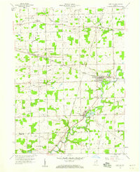
1956 Map of Cedarville
USGS Topo · Published 1958About this map
Cedarville Reservoir and the St Joseph River dominate this mid-century landscape northeast of Fort Wayne, marking a period of significant local infrastructure and institutional growth. The community of Leo serves as a northern anchor, featuring a Twp High Sch and multiple cemeteries, while Cedarville sits at the southern edge of the reservoir. Educational and religious institutions are prominent throughout the area, including Sr Concordia College and the Sacred Heart Seminaries in the southwest. The terrain is defined by a dense network of drainage projects such as Warner Ditch and Alex Ditch, supporting the agricultural character of Perry and Cedar townships. Evidence of earlier water management remains visible in the St Joe Canal, while modern utilities are represented by a Radio Tower and Substation near Bouries.
Find a feature on this map
60 named features on this map. Tap any name to fly to it.
Don’t see what you’re looking for? This feature index may not catch every label — zoom into the map to look around manually.
Map Details
Editions of this 1956 Cedarville Map
This is the sole edition of this map. No revisions or reprints were ever made.
Other maps of this area

1953 · Fort Wayne
USGS Topo · 1:250,000

1956 · Fort Wayne
USGS Topo · 1:250,000

1956 · Fort Wayne West
USGS Topo · 1:24,000

1956 · Fort Wayne East
USGS Topo · 1:24,000

1957 · Auburn
USGS Topo · 1:24,000

1957 · Maples
USGS Topo · 1:24,000

1957 · Huntertown
USGS Topo · 1:24,000

1957 · Garrett
USGS Topo · 1:24,000

1958 · Grabill
USGS Topo · 1:24,000
1958 · Saint Joe
USGS Topo · 1:24,000