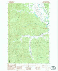
1986 Map of Cedarville
USGS Topo · Published 1994About this map
The Chehalis River winds through the eastern edge of this terrain, marking a boundary near the small settlement of Cedarville. The landscape is dominated by a complex network of drainage basins, including Garrard Creek and its South Fork, which carve through the dense woodlands of the Capitol State Forest. This mid-1980s topography reveals an environment shaped by both natural waterways and human industry, evidenced by numerous Borrow Pits and an Old Grade Road that speaks to the area's timber or transit history.
Find a feature on this map
21 named features on this map. Tap any name to fly to it.
Don’t see what you’re looking for? This feature index may not catch every label — zoom into the map to look around manually.
Map Details
Editions of this 1986 Cedarville Map
2 editions found
Other maps of this area

1941 · Walville
USGS Topo · 1:62,500

1941 · Meskill
USGS Topo · 1:62,500

1941 · Gate
USGS Topo · 1:62,500

1941 · Ford
USGS Topo · 1:62,500

1953 · Hoquiam
USGS Topo · 1:250,000

1953 · Rochester
USGS Topo · 1:62,500

1953 · Pe Ell
USGS Topo · 1:62,500

1953 · Malone
USGS Topo · 1:62,500

1953 · Adna
USGS Topo · 1:62,500

1957 · Hoquiam
USGS Topo · 1:250,000