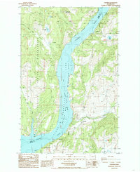
1985 Map of Cedonia
USGS Topo · Published 1985About this map
Franklin D. Roosevelt Lake dominates this mid-1980s landscape, serving as the boundary between Ferry and Stevens counties. On the western shore, the Colville Indian Reservation contains the small community of Covada and the mining interests at Longstreet Mine and Silver Leaf Mine near the base of Rattlesnake Mtn. This area reflects the mid-century transformation of the upper Columbia River following the construction of Grand Coulee Dam, which created the reservoir and the surrounding Franklin D. Roosevelt Lake National Recreation Area.
Find a feature on this map
20 named features on this map. Tap any name to fly to it.
Don’t see what you’re looking for? This feature index may not catch every label — zoom into the map to look around manually.
Map Details
Editions of this 1985 Cedonia Map
2 editions found
Other maps of this area

1948 · Hunters
USGS Topo · 1:62,500

1948 · Wilmont Creek
USGS Topo · 1:62,500

1950 · Wilmont Creek
USGS Topo · 1:62,500

1950 · Hunters
USGS Topo · 1:62,500

1950 · Inchelium
USGS Topo · 1:62,500

1952 · Twin Lakes
USGS Topo · 1:62,500

1954 · Okanogan
USGS Topo · 1:250,000

1956 · Wilmont Creek
USGS Topo · 1:62,500

1958 · Okanogan
USGS Topo · 1:250,000

1984 · Nespelem
USGS Topo · 1:100,000