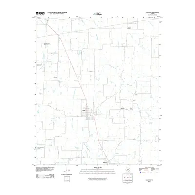
2010 Map of Celeste
USGS Topo · Published 2010About this map
Celeste serves as a central hub in this Northeast Texas landscape, where the grid of rural roads connects several small communities and family landmarks. The area is defined by the headwaters of major Texas river systems, notably the South Sulphur River and the Cowleech Fork Sabine River, which create a complex drainage network across the terrain. Genealogists will find significant local history at the Nicholson Cemetery and Celeste Cemetery, while the small settlements of Hogeye and Midway illustrate the dispersed nature of local agricultural commerce. The northern edge touches Leonard, while the southern reaches extend toward Kingston. This survey also documents mid-century infrastructure improvements, such as the Soil Conservation Service Site 60 Dam and other water management sites, alongside the Chambers Airport near the western boundary.
Find a feature on this map
73 named features on this map. Tap any name to fly to it.
Don’t see what you’re looking for? This feature index may not catch every label — zoom into the map to look around manually.
Map Details
Editions of this 2010 Celeste Map
This is the sole edition of this map. No revisions or reprints were ever made.
Other maps of this area

1930 · Farmersville
USGS Topo · 1:62,500

1954 · Sherman
USGS Topo · 1:250,000

1958 · Sherman
USGS Topo · 1:250,000

1960 · Pike
USGS Topo · 1:24,000

1962 · Greenville NW
USGS Topo · 1:24,000

1962 · Farmersville
USGS Topo · 1:24,000

1963 · Greenville NE
USGS Topo · 1:24,000

1964 · Trenton
USGS Topo · 1:24,000

1964 · Celeste
USGS Topo · 1:24,000
1964 · Gober
USGS Topo · 1:24,000