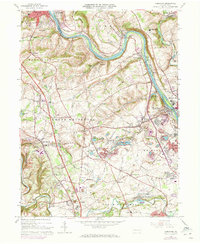
1964 Map of Cementon
USGS Topo · Published 1973About this map
The Lehigh River snakes through this industrial and agricultural corridor during the early 1970s, serving as a boundary for several townships including Washington and North Whitehall. The landscape is defined by its industrial heritage, particularly in the namesake Cementon and surrounding areas like Egypt and Ormrod, where the Dewey Heights Quarry and numerous unnamed quarries point to the region's mineral wealth. Transportation infrastructure is dense, with the Lehigh Valley Railroad, Central Railroad of New Jersey, and Reading Railroad all competing for space along the riverbanks and through the valley.
Find a feature on this map
100 named features on this map. Tap any name to fly to it.
Don’t see what you’re looking for? This feature index may not catch every label — zoom into the map to look around manually.
Map Details
Editions of this 1964 Cementon Map
Other maps of this area

1894 · Allentown
USGS Topo · 1:62,500

1902 · Slatington
USGS Topo · 1:62,500

1914 · Wind Gap
USGS Topo · 1:62,500

1916 · Wind Gap
USGS Topo · 1:62,500

1922 · Mauch Chunk
USGS Topo · 1:62,500

1924 · Mauch Chunk
USGS Topo · 1:62,500

1937 · Allentown West
USGS Topo · 1:48,000

1939 · Allentown
USGS Topo · 1:62,500

1942 · Allentown West
USGS Topo · 1:62,500

1943 · Mauch Chunk
USGS Topo · 1:62,500