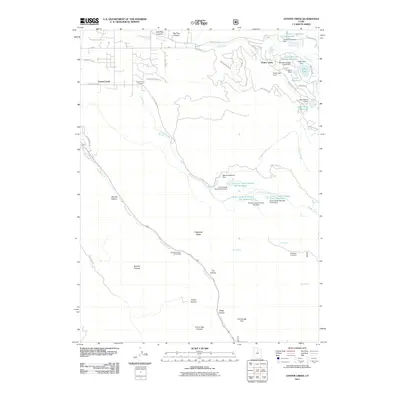
2011 Map of Center Creek
USGS Topo · Published 2011About this map
Center Creek and the residential community of Timber Lakes dominate this portion of the Wasatch landscape, where water management is a central feature of the terrain. The high-elevation topography is defined by an intricate network of dams and reservoirs, including the Lower Bennett Lindsay Reservoir and several numbered basins along the upper reaches of the creek. These structures underscore the region's historical and ongoing reliance on managed water systems to support both local settlements and agriculture. In the lower valleys, Center Creek Cemetery serves as a significant landmark for genealogical research near the junction of E Center Creek Rd. The southeastern portion of the map transitions into deep drainages like Daniels Canyon and Clegg Canyon, while high points such as Hogsback Ridge and the Hogsback Exclosure indicate specialized land use and conservation efforts in the early 21st century.
Find a feature on this map
57 named features on this map. Tap any name to fly to it.
Don’t see what you’re looking for? This feature index may not catch every label — zoom into the map to look around manually.
Map Details
Editions of this 2011 Center Creek Map
This is the sole edition of this map. No revisions or reprints were ever made.
Other maps of this area

1885 · Salt Lake
USGS Topo · 1:250,000

1900 · Coalville
USGS Topo · 1:125,000

1903 · Coalville
USGS Topo · 1:125,000

1907 · Strawberry Valley
USGS Topo · 1:125,000

1909 · Strawberry Valley
USGS Topo · 1:125,000

1954 · Salt Lake City
USGS Topo · 1:250,000

1955 · Heber
USGS Topo · 1:24,000

1958 · Salt Lake City
USGS Topo · 1:250,000

1960 · Salt Lake City
USGS Topo · 1:250,000
1966 · Charleston
USGS Topo · 1:24,000