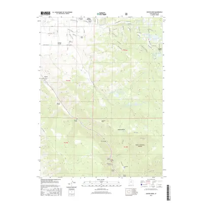
2017 Map of Center Creek
USGS Topo · Published 2017About this map
Center Creek sits at the base of the high country east of the Heber Valley, where mountain drainage is carefully managed through a network of reservoirs. This 2017 study illustrates the complex water systems serving the region, including the Center Creek Number One Reservoir, Center Creek Number Two Reservoir, and Center Creek Number Three Reservoir. To the east, the residential expansion of Timber Lakes is visible, situated near Deer Valley Reservoir and Witts Lake. The southern half of the map is dominated by the steep terrain of the Uinta National Forest, characterized by deep cuts like Clegg Canyon and Parker Canyon. The presence of the Center Creek Cem near the valley floor provides a focal point for local genealogical research, while landmarks such as Hogsback Ridge and Cummings Flat define the transition from the valley floor to the protected forest lands.
Find a feature on this map
76 named features on this map. Tap any name to fly to it.
Don’t see what you’re looking for? This feature index may not catch every label — zoom into the map to look around manually.
Map Details
Editions of this 2017 Center Creek Map
This is the sole edition of this map. No revisions or reprints were ever made.
Other maps of this area

1885 · Salt Lake
USGS Topo · 1:250,000

1900 · Coalville
USGS Topo · 1:125,000

1903 · Coalville
USGS Topo · 1:125,000

1907 · Strawberry Valley
USGS Topo · 1:125,000

1909 · Strawberry Valley
USGS Topo · 1:125,000

1954 · Salt Lake City
USGS Topo · 1:250,000

1955 · Heber
USGS Topo · 1:24,000

1958 · Salt Lake City
USGS Topo · 1:250,000

1960 · Salt Lake City
USGS Topo · 1:250,000
1966 · Charleston
USGS Topo · 1:24,000