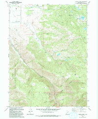
1993 Map of Center Creek
USGS Topo · Published 1993About this map
Heber Valley provides a transition between the valley floor and the rising canyons of the Wasatch range. The settlement of Center Creek sits at the base of the mountains, marked by its local Cem and water infrastructure, while the residential enclave of Timber Lakes occupies the higher elevations near Witts Lake and Jones Reservoir. This landscape is defined by the heavy presence of public lands, split between the Uinta National Forest and the Wallsburg State Wildlife Management Area.
Find a feature on this map
37 named features on this map. Tap any name to fly to it.
Don’t see what you’re looking for? This feature index may not catch every label — zoom into the map to look around manually.
Map Details
Editions of this 1993 Center Creek Map
This is the sole edition of this map. No revisions or reprints were ever made.
Other maps of this area

1885 · Salt Lake
USGS Topo · 1:250,000

1900 · Coalville
USGS Topo · 1:125,000

1903 · Coalville
USGS Topo · 1:125,000

1907 · Strawberry Valley
USGS Topo · 1:125,000

1909 · Strawberry Valley
USGS Topo · 1:125,000

1954 · Salt Lake City
USGS Topo · 1:250,000

1955 · Heber
USGS Topo · 1:24,000

1958 · Salt Lake City
USGS Topo · 1:250,000

1960 · Salt Lake City
USGS Topo · 1:250,000
1966 · Charleston
USGS Topo · 1:24,000