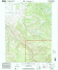
1998 Map of Center Creek
USGS Topo · Published 2000About this map
Center Creek flows from the high ridges of the Uinta National Forest toward the Heber Valley, defining the drainage of this Wasatch County landscape. By the late 1990s, the terrain shows a mix of recreational development and historical mountain industry, with Timber Lakes and Witts Lake situated near Jones Reservoir in the eastern uplands. The topographic detail captures the transition from the irrigated valley floor to the steep Hogsback and the protected lands of the Wallsburg State Wildlife Management Area. Numerous natural water sources, such as Whiskey Spring and Cold Spring, are mapped along the winding route of Daniels Canyon. Evidence of local work remains visible through the Gravel Pit, various Quarries, and several Corrals, while family-named landmarks like Cummings Flat and Parker indicate the area's grazing and settlement history.
Find a feature on this map
41 named features on this map. Tap any name to fly to it.
Don’t see what you’re looking for? This feature index may not catch every label — zoom into the map to look around manually.
Map Details
Editions of this 1998 Center Creek Map
This is the sole edition of this map. No revisions or reprints were ever made.
Other maps of this area

1885 · Salt Lake
USGS Topo · 1:250,000

1900 · Coalville
USGS Topo · 1:125,000

1903 · Coalville
USGS Topo · 1:125,000

1907 · Strawberry Valley
USGS Topo · 1:125,000

1909 · Strawberry Valley
USGS Topo · 1:125,000

1954 · Salt Lake City
USGS Topo · 1:250,000

1955 · Heber
USGS Topo · 1:24,000

1958 · Salt Lake City
USGS Topo · 1:250,000

1960 · Salt Lake City
USGS Topo · 1:250,000
1966 · Charleston
USGS Topo · 1:24,000