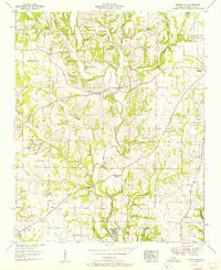
1952 Map of Center Hill
USGS Topo · Published 1957About this map
Bluewater Creek and its many tributaries, including Keaty Branch and Richardson Creek, dominate this rural Lauderdale County landscape during the early 1950s. The settlement of Lexington appears in the northeast, while smaller communities like Center Hill, Arkdell, and Michael are connected by a network of local roads. The map reveals a high density of community institutions that suggest a closely-knit social fabric, featuring numerous rural schools such as Sweet Gum Sch and Palestine Sch, alongside a variety of houses of worship including Greens Chapel Flat Church and the North Carolina Church. A notable industrial or specialized agricultural feature is the Minnow Hatchery located near Mitchelltown, situated along the creek beds that define the local topography. Genealogists will find significant value in the documentation of family-named burial grounds like Pettus Cem, Scott Cem, and Stutts Cem.
Find a feature on this map
69 named features on this map. Tap any name to fly to it.
Don’t see what you’re looking for? This feature index may not catch every label — zoom into the map to look around manually.
Map Details
Editions of this 1952 Center Hill Map
3 editions found
Other maps of this area

1905 · Waynesboro
USGS Topo · 1:125,000

1914 · Rogersville
USGS Topo · 1:48,000

1914 · Muscle Shoals
USGS Topo · 1:48,000

1916 · Muscle Shoals
USGS Topo · 1:62,500

1916 · Rogersville
USGS Topo · 1:62,500

1936 · Thorntontown
USGS Topo · 1:24,000

1936 · Lexington
USGS Topo · 1:24,000

1936 · Loretto
USGS Topo · 1:24,000

1936 · Pruitton
USGS Topo · 1:24,000

1936 · Wheeler Dam
USGS Topo · 1:24,000