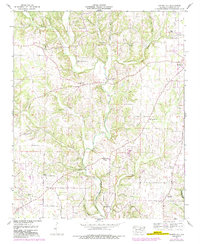
1952 Map of Center Hill
USGS Topo · Published 1989About this map
Bluewater Creek and its many tributaries, including Little Bluewater Creek and Richardson Creek, carve a complex drainage pattern across this corner of Lauderdale County. The landscape is defined by its rural community structures, with a high density of country churches such as Greene Chapel, Richardson Chapel, and Sweet Gum Flat Church serving as local anchors. Settlement is dispersed across high ground between the hollows, with small hubs at Center Hill, Arkdell, and Mitchelltown. To the northeast, the corporate boundary of Lexington begins to encroach on the traditional farmland. Significant for genealogists, the area is dotted with family-named landmarks and resting places, including Pettus Cem, Grissom Cem, and Stutts Cem. Natural water sources like McGuire Spring and Worley Spring underscore the importance of local hydrology to the original farmstead locations in this mid-century period.
Find a feature on this map
45 named features on this map. Tap any name to fly to it.
Don’t see what you’re looking for? This feature index may not catch every label — zoom into the map to look around manually.
Map Details
Editions of this 1952 Center Hill Map
3 editions found
Other maps of this area

1905 · Waynesboro
USGS Topo · 1:125,000

1914 · Rogersville
USGS Topo · 1:48,000

1914 · Muscle Shoals
USGS Topo · 1:48,000

1916 · Muscle Shoals
USGS Topo · 1:62,500

1916 · Rogersville
USGS Topo · 1:62,500

1936 · Thorntontown
USGS Topo · 1:24,000

1936 · Lexington
USGS Topo · 1:24,000

1936 · Loretto
USGS Topo · 1:24,000

1936 · Pruitton
USGS Topo · 1:24,000

1936 · Wheeler Dam
USGS Topo · 1:24,000