1968 Map of Center Point
USGS Topo · Published 1983About this map
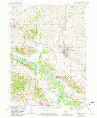
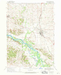
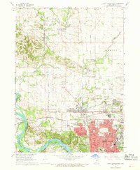
The Cedar River carves a winding path through the center of this landscape, creating a complex wetland environment in the Fayette Bottoms. These lowlands are dotted with numerous small lakes and basins, including Goose Pond, Little Lewis Lake, and Big Lewis Lake, providing a sharp contrast to the upland agricultural fields of Benton and Linn Co. This 1968 survey (with 1982 revisions) shows the conversion of transportation infrastructure, notably the Cedar Valley Nature Trail occupying the former Old Railroad Grade north of Center Point. Local history is anchored by several rural landmarks, including Cedar Ridge Ch and cemeteries like Davis Cem and McBroom Cem. The development of Pleasant Creek State Park in the southwest corner indicates a mid-century shift toward public recreation and conservation along the river corridor.
Find a feature on this map
35 named features on this map. Tap any name to fly to it.
Don’t see what you’re looking for? This feature index may not catch every label — zoom into the map to look around manually.
Map Details
Editions of this 1968 Center Point Map
2 editions found
Other maps of this area

1888 · Shellsburg
USGS Topo · 1:62,500

1888 · Marion
USGS Topo · 1:62,500

1889 · Marion
USGS Topo · 1:62,500

1889 · Shellsburg
USGS Topo · 1:62,500

1899 · Shellsburg
USGS Topo · 1:62,500

1903 · Winthrop
USGS Topo · 1:125,000

1959 · Dubuque
USGS Topo · 1:250,000

1961 · Dubuque
USGS Topo · 1:250,000

1962 · Dubuque
USGS Topo · 1:250,000
1967 · Cedar Rapids North
USGS Topo · 1:24,000