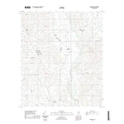
2020 Map of Center Ridge
USGS Topo · Published 2020About this map
The community of Center Ridge serves as a central hub in this modern topographic study of eastern Smith County, where the landscape is defined by the winding course of the Leaf River and its many tributaries. This region of Mississippi maintains its rural character through an extensive network of county roads, including Co RD 84 and Co RD 90, which connect scattered homesteads and significant local institutions. The map is particularly notable for its dense concentration of Baptist and Methodist congregations, many of which are associated with long-standing family burial grounds.
Find a feature on this map
66 named features on this map. Tap any name to fly to it.
Don’t see what you’re looking for? This feature index may not catch every label — zoom into the map to look around manually.
Map Details
Editions of this 2020 Center Ridge Map
This is the sole edition of this map. No revisions or reprints were ever made.
Other maps of this area

1953 · Hattiesburg
USGS Topo · 1:250,000

1953 · Meridian
USGS Topo · 1:250,000

1957 · Meridian
USGS Topo · 1:250,000

1958 · Hattiesburg
USGS Topo · 1:250,000

1965 · Meridian
USGS Topo · 1:250,000

1968 · Raleigh
USGS Topo · 1:24,000

1968 · Louin
USGS Topo · 1:24,000

1968 · Louin SW
USGS Topo · 1:24,000

1974 · Soso
USGS Topo · 1:24,000
1974 · Bay Springs
USGS Topo · 1:24,000