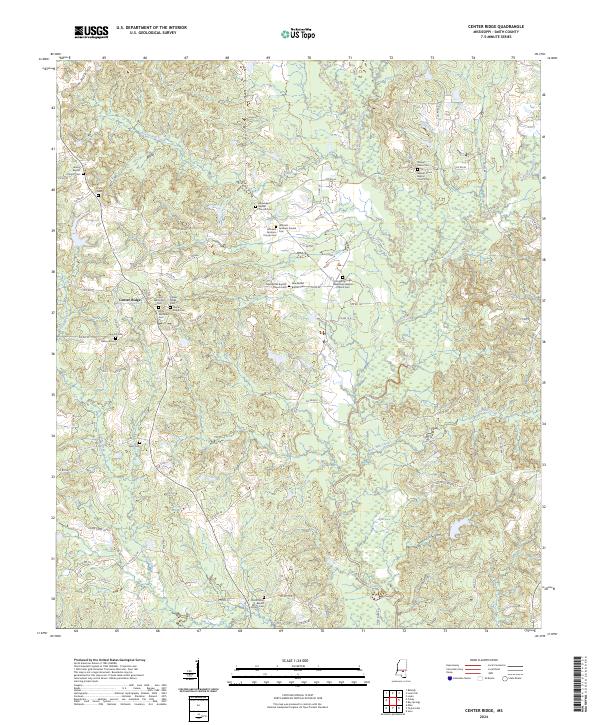
2024 Map of Center Ridge
USGS Topo · Published 2024About this map
The community of Center Ridge serves as the focal point for this landscape in the northern reaches of Smith County, where a dense network of country roads connects family settlements and historic congregations. The area is heavily defined by its spiritual and genealogical landmarks, including the Mount Zion Baptist Church Cem and the Liberty Baptist Church Cem. Small family burial sites like Hancock Cem and the Jeffcoats - Farnham Private Cem are scattered among the ridges, suggesting deep-rooted local lineages. The drainage patterns of the Leaf River and Beaverdam Creek dictate the local topography, while the eastern portion of the sheet is marked by the winding courses of West Tallahala Creek and Keys Mill Creek. This distribution of cemeteries and churches across the various townships—t2n r8e, t2n r9e, t1n r8e, and t1n r9e—reflects a classic rural Mississippi settlement pattern of small, dispersed communities centered around place of worship and kinship.
Find a feature on this map
114 named features on this map. Tap any name to fly to it.
Don’t see what you’re looking for? This feature index may not catch every label — zoom into the map to look around manually.
Map Details
Editions of this 2024 Center Ridge Map
This is the sole edition of this map. No revisions or reprints were ever made.
Other maps of this area

1953 · Hattiesburg
USGS Topo · 1:250,000

1953 · Meridian
USGS Topo · 1:250,000

1957 · Meridian
USGS Topo · 1:250,000

1958 · Hattiesburg
USGS Topo · 1:250,000

1965 · Meridian
USGS Topo · 1:250,000

1968 · Raleigh
USGS Topo · 1:24,000

1968 · Louin
USGS Topo · 1:24,000

1968 · Louin SW
USGS Topo · 1:24,000

1974 · Soso
USGS Topo · 1:24,000
1974 · Bay Springs
USGS Topo · 1:24,000