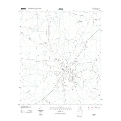
2013 Map of Center
USGS Topo · Published 2013About this map
The Deep East Texas settlement of Center serves as the hub of this East Texas survey, where established thoroughfares like FM 699 and Spur 699 converge. The surrounding landscape is defined by a dense network of watercourses, including the winding Chicken Bayou to the north and Huana Cr to the south. This 2013 record is particularly valuable for genealogists, as it meticulously identifies numerous family and community burial sites such as Cedar Yard Cem, Newburn Cem, and Asbury Chapel Cem near the settlement of North Jericho. The map details the transition from the concentrated residential streets of the city center to the outlying timber and pasture lands, reached via routes like Cotton Ford RD and Henrietta RD. Modern infrastructure is also present, notably the Center Municipal Airport and the development surrounding State Loop 500.
Find a feature on this map
158 named features on this map. Tap any name to fly to it.
Don’t see what you’re looking for? This feature index may not catch every label — zoom into the map to look around manually.
Map Details
Editions of this 2013 Center Map
This is the sole edition of this map. No revisions or reprints were ever made.
Other maps of this area

1953 · Palestine
USGS Topo · 1:250,000

1957 · Palestine
USGS Topo · 1:250,000

1958 · Center
USGS Topo · 1:62,500

1958 · San Augustine
USGS Topo · 1:62,500

1958 · Martinsville
USGS Topo · 1:62,500

1958 · Timpson
USGS Topo · 1:62,500

1984 · Palestine
USGS Topo · 1:250,000
1984 · Logansport West
USGS Topo · 1:24,000
1984 · Center
USGS Topo · 1:24,000
1984 · Hurstown
USGS Topo · 1:24,000