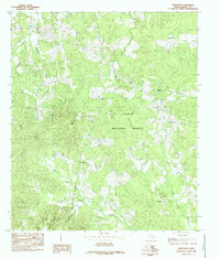
1984 Map of Hurstown
USGS Topo · Published 1985About this map
Sabine National Forest dominates this section of Shelby County, where a complex network of waterways defines the landscape. The settlement of Hurstown sits near Doggett Spring, while further south, the communities of East Liberty and Mc Clelland are established along the winding path of Bayou Patroon. This survey captures the rural character of the region in the mid-1980s, documenting a terrain punctuated by elevations like Big Hill and numerous named tributaries. The placement of a Cem in the northeast suggests a long-standing local history tied to these forest clearings. The intricate drainage pattern, featuring Bayou Siepe, Crooked Creek, and Lick Creek, illustrates the hydrological importance of this area within the larger Texas river systems.
Find a feature on this map
23 named features on this map. Tap any name to fly to it.
Don’t see what you’re looking for? This feature index may not catch every label — zoom into the map to look around manually.
Map Details
Editions of this 1984 Hurstown Map
This is the sole edition of this map. No revisions or reprints were ever made.
Other maps of this area

1944 · Logansport
USGS Topo · 1:62,500

1944 · Patroon
USGS Topo · 1:62,500

1953 · Alexandria
USGS Topo · 1:250,000

1953 · Palestine
USGS Topo · 1:250,000

1955 · Alexandria
USGS Topo · 1:250,000

1956 · Logansport
USGS Topo · 1:62,500

1956 · Patroon
USGS Topo · 1:62,500

1957 · Palestine
USGS Topo · 1:250,000

1958 · Center
USGS Topo · 1:62,500

1958 · San Augustine
USGS Topo · 1:62,500