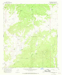
1965 Map of Centerfire Bog
USGS Topo · Published 1968About this map
Apache National Forest and Gila National Forest converge in this high-altitude landscape of western New Mexico. The terrain is defined by a sophisticated network of water management features essential for ranching and survival in the arid high country, including numerous man-made catchments like Dead Horse Tank, Freeman Tank No 2, and East Camp Tank. The presence of named water sources such as Rita Blanca Spring and Todd Browning Spring suggests a reliance on perennial flows for the livestock that grazed these canyons.
Find a feature on this map
43 named features on this map. Tap any name to fly to it.
Don’t see what you’re looking for? This feature index may not catch every label — zoom into the map to look around manually.
Map Details
Editions of this 1965 Centerfire Bog Map
2 editions found
Other maps of this area

1915 · Reserve
USGS Topo · 1:125,000

1918 · Reserve
USGS Topo · 1:125,000

1954 · Clifton
USGS Topo · 1:250,000

1954 · Saint Johns
USGS Topo · 1:250,000

1957 · Clifton
USGS Topo · 1:250,000

1957 · Saint Johns
USGS Topo · 1:250,000

1958 · Clifton
USGS Topo · 1:250,000

1958 · Saint Johns
USGS Topo · 1:250,000

1962 · Clifton
USGS Topo · 1:250,000

1962 · Saint Johns
USGS Topo · 1:250,000