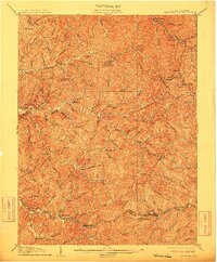
1905 Map of Centerpoint
USGS Topo · Published 1912About this map
The Baltimore and Ohio RR anchors the southern portion of this landscape, connecting the industrial nodes of Salem and Smithton at the turn of the century. This survey, conducted under George Otis Smith and state geologist I.C. White, reveals a densely dissected plateau where nearly every hollow and ridge bears the name of a local family or early settler. Small post offices and railway stations like Alvy P.O. Stringtown and Braden Sta. Lima P.O. illustrate the fragmented but interconnected nature of rural life before major highway development.
Find a feature on this map
117 named features on this map. Tap any name to fly to it.
Don’t see what you’re looking for? This feature index may not catch every label — zoom into the map to look around manually.
Map Details
Editions of this 1905 Centerpoint Map
3 editions found
Other maps of this area

1902 · Clarksburg
USGS Topo · 1:62,500

1903 · Littleton
USGS Topo · 1:62,500

1904 · Weston
USGS Topo · 1:62,500

1904 · Vadis
USGS Topo · 1:62,500

1905 · Mannington
USGS Topo · 1:62,500

1905 · Centerpoint
USGS Topo · 1:62,500

1905 · West Union
USGS Topo · 1:62,500

1905 · Littleton
USGS Topo · 1:62,500

1906 · Holbrook
USGS Topo · 1:62,500

1906 · New Martinsville
USGS Topo · 1:62,500