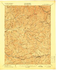
1905 Map of Centerpoint
USGS Topo · Published 1918About this map
Salem and Smithfield anchor this topographic study of the West Virginia interior, captured just after the turn of the century when the regional economy was defined by the Baltimore and Ohio RR. The rail corridor through the southern reaches connects industrial outposts like Industrial and Sherwood, passing through a series of steep drainages including Meathouse Fork and Buckeye Run. The map reveals a dense network of mountain post offices and small settlements such as Alvy P.O. Stringtown and Braden Sta. Lima P.O., which served the remote hollows and ridges of Doddridge, Wetzel, and Tyler counties.
Find a feature on this map
119 named features on this map. Tap any name to fly to it.
Don’t see what you’re looking for? This feature index may not catch every label — zoom into the map to look around manually.
Map Details
Editions of this 1905 Centerpoint Map
3 editions found
Other maps of this area

1902 · Clarksburg
USGS Topo · 1:62,500

1903 · Littleton
USGS Topo · 1:62,500

1904 · Weston
USGS Topo · 1:62,500

1904 · Vadis
USGS Topo · 1:62,500

1905 · Mannington
USGS Topo · 1:62,500

1905 · Centerpoint
USGS Topo · 1:62,500

1905 · West Union
USGS Topo · 1:62,500

1905 · Littleton
USGS Topo · 1:62,500

1906 · Holbrook
USGS Topo · 1:62,500

1906 · New Martinsville
USGS Topo · 1:62,500