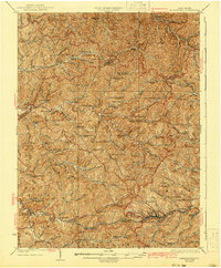
1925 Map of Centerpoint
USGS Topo · Published 1941About this map
Centerpoint serves as the geographic heart of this mid-1920s landscape, where the deeply dissected plateau of Doddridge and Harrison Counties is defined by an incredibly dense network of hollows and ridge-line communities. The southern edge of the map is anchored by the Baltimore and Ohio railroad corridor, connecting Smithton Smithburg Sta, Morgansville, and Salem. This rail link contrasts with the remote northern reaches where small post offices like Alvy PO and Lima PO served isolated rural populations.
Find a feature on this map
160 named features on this map. Tap any name to fly to it.
Don’t see what you’re looking for? This feature index may not catch every label — zoom into the map to look around manually.
Map Details
Editions of this 1925 Centerpoint Map
4 editions found

Other maps of this area

1902 · Clarksburg
USGS Topo · 1:62,500

1903 · Littleton
USGS Topo · 1:62,500

1904 · Weston
USGS Topo · 1:62,500

1904 · Vadis
USGS Topo · 1:62,500

1905 · Mannington
USGS Topo · 1:62,500

1905 · Centerpoint
USGS Topo · 1:62,500

1905 · West Union
USGS Topo · 1:62,500

1905 · Littleton
USGS Topo · 1:62,500

1906 · Holbrook
USGS Topo · 1:62,500

1906 · New Martinsville
USGS Topo · 1:62,500