
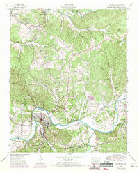
1952 Map of Centertown
USGS Topo · Published 1957About this map
The Duck River snakes through the heart of the region, defining the landscape with deep meanders like Eason Bend, Tottys Bend, and Shipp Bend. The county seat of Centerville serves as the primary hub, surrounded by outlying communities such as Nunnelly and Woodland Heights. The industrial character of the mid-20th century is evident in the presence of the Nunnelly Mines and several strip mines, while the area's transportation history is recorded via the Goodrich Railroad and the Nashville and Chattanooga line.
Find a feature on this map
109 named features on this map. Tap any name to fly to it.
Don’t see what you’re looking for? This feature index may not catch every label — zoom into the map to look around manually.
Map Details
Editions of this 1952 Centertown Map
2 editions found
Other maps of this area

1893 · Mc Minnville
USGS Topo · 1:125,000

1895 · Mc Minnville
USGS Topo · 1:125,000

1908 · Woodbury
USGS Topo · 1:62,500

1913 · Hollow Springs
USGS Topo · 1:62,500

1936 · Fredonia
USGS Topo · 1:24,000

1936 · Petty Gap
USGS Topo · 1:24,000

1936 · Morrison
USGS Topo · 1:24,000

1942 · Statesville
USGS Topo · 1:100,000

1943 · Mc Minnville
USGS Topo · 1:100,000

1953 · Chattanooga
USGS Topo · 1:250,000