
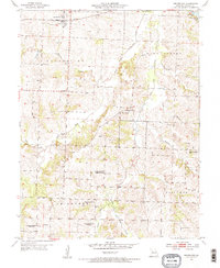
1954 Map of Centerview
USGS Topo · Published 1955About this map
Centerview serves as the central hub of this mid-century Missouri landscape, situated along the Pacific railroad line. The surrounding countryside in the mid-1950s was defined by a network of rural schools and churches that anchored small farming communities. Many of these local landmarks were already in transition at the time of the survey, as evidenced by several marked as abandoned, including Locust Grove Sch, Science Hill Sch, and Hazel Mound Sch.
Find a feature on this map
26 named features on this map. Tap any name to fly to it.
Don’t see what you’re looking for? This feature index may not catch every label — zoom into the map to look around manually.
Map Details
Editions of this 1954 Centerview Map
2 editions found
Other maps of this area

1885 · Warrensburg
USGS Topo · 1:125,000

1887 · Warrensburg
USGS Topo · 1:125,000

1894 · Warrensburg
USGS Topo · 1:125,000

1917 · Knobnoster
USGS Topo · 1:62,500

1947 · Jefferson City
USGS Topo · 1:250,000

1954 · Jefferson City
USGS Topo · 1:250,000
1954 · Holden
USGS Topo · 1:24,000
1955 · Leeton
USGS Topo · 1:24,000

1955 · Cornelia
USGS Topo · 1:24,000
1955 · Chilhowee
USGS Topo · 1:24,000