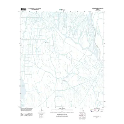
2012 Map of Centerville NE
USGS Topo · Published 2012About this map
The intricate wetlands of Iberia Parish are defined by a complex web of waterways and energy extraction sites in this early 21st-century landscape. Central to the area's geography is the Old River and Bayou Long, which anchor a network of secondary channels such as Wildcat Bayou and Little Bayou Mallet. This period in the region's history shows significant industrial infrastructure integrated into the natural hydrology, specifically through the Bayou Postillion Oil Field and the Mystic Bayou Gas Field. Human settlement is concentrated at Population Bend, situated along a bend in the river near Levee Rd. The map also illustrates the convergence of multiple branches of the Bayou Long system, including the Middle Fork and W Fork, providing a detailed look at the drainage patterns and water navigation routes like Keelboat Pass during this era.
Find a feature on this map
21 named features on this map. Tap any name to fly to it.
Don’t see what you’re looking for? This feature index may not catch every label — zoom into the map to look around manually.
Map Details
Editions of this 2012 Centerville NE Map
This is the sole edition of this map. No revisions or reprints were ever made.
Other maps of this area

1935 · Chicot Lake
USGS Topo · 1:62,500

1936 · White Castle
USGS Topo · 1:62,500

1945 · New Orleans
USGS Topo · 1:250,000

1948 · Foster
USGS Topo · 1:62,500

1953 · Napoleonville
USGS Topo · 1:62,500

1954 · Chicot Lake
USGS Topo · 1:62,500

1954 · Baton Rouge
USGS Topo · 1:250,000
1955 · Chicot Lake
USGS Topo · 1:62,500

1956 · Baton Rouge
USGS Topo · 1:250,000

1959 · Foster
USGS Topo · 1:62,500