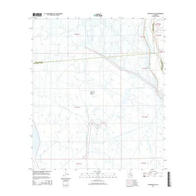
2015 Map of Centerville NE
USGS Topo · Published 2015About this map
The Atchafalaya Basin Floodway dominates this landscape, where the shifting hydrology of southern Louisiana is managed through a complex network of bayous and engineered channels. This 2015 survey reveals how the Intracoastal Waterway and the Gulf Intracoastal Waterway intersect the natural drainage patterns of the basin, facilitating modern maritime transit through the wetlands. The convergence of Iberia, Assumption, and St. Martin parish lines within this watery expanse highlights the administrative complexity of the region. Local water bodies including Bayou Long, Old River, and Bayou Postillion form an intricate labyrinth of channels. These waterways, ranging from the Middle Fork Bayou Long to Little Bayou Mallet, represent the traditional corridors of travel and transport in a region where solid ground is at a premium.
Find a feature on this map
27 named features on this map. Tap any name to fly to it.
Don’t see what you’re looking for? This feature index may not catch every label — zoom into the map to look around manually.
Map Details
Editions of this 2015 Centerville NE Map
This is the sole edition of this map. No revisions or reprints were ever made.
Other maps of this area

1935 · Chicot Lake
USGS Topo · 1:62,500

1936 · White Castle
USGS Topo · 1:62,500

1945 · New Orleans
USGS Topo · 1:250,000

1948 · Foster
USGS Topo · 1:62,500

1953 · Napoleonville
USGS Topo · 1:62,500

1954 · Chicot Lake
USGS Topo · 1:62,500

1954 · Baton Rouge
USGS Topo · 1:250,000
1955 · Chicot Lake
USGS Topo · 1:62,500

1956 · Baton Rouge
USGS Topo · 1:250,000

1959 · Foster
USGS Topo · 1:62,500