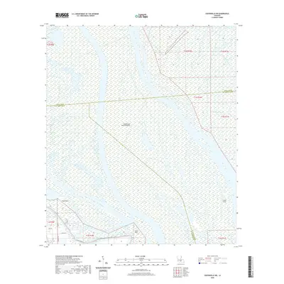
2020 Map of Centerville NW
USGS Topo · Published 2020About this map
The Atchafalaya Basin Floodway dominates this coastal Louisiana landscape, revealing the intricate water-and-land interface of Iberia and St. Martin Parishes. This 2020 survey documents a complex network of wetlands and waterways, including Turkey Island and Shaws Island, situated within a broader hydrologic system managed by the W Atchafalaya Basin Spillway Levee. The map shows how infrastructure adapts to this environment, with roads like Pan Am Rd and Bellview Front St hugging the edge of the flood protection system. Remote bayous such as Big Bayou Pigeon and Smith Bayou wind through the basin, marking traditional routes through the swamp. Along the southern margin, small-scale access is noted by local names like Millet Point and Taylor Point, providing a contemporary record of this shifting deltaic region.
Find a feature on this map
26 named features on this map. Tap any name to fly to it.
Don’t see what you’re looking for? This feature index may not catch every label — zoom into the map to look around manually.
Map Details
Editions of this 2020 Centerville NW Map
This is the sole edition of this map. No revisions or reprints were ever made.
Other maps of this area

1935 · Chicot Lake
USGS Topo · 1:62,500

1937 · Jeanerette
USGS Topo · 1:62,500

1941 · Loreauville
USGS Topo · 1:62,500

1945 · New Orleans
USGS Topo · 1:250,000

1948 · Foster
USGS Topo · 1:62,500

1954 · Chicot Lake
USGS Topo · 1:62,500

1954 · Loreauville
USGS Topo · 1:62,500

1954 · Jeanerette
USGS Topo · 1:62,500

1954 · Baton Rouge
USGS Topo · 1:250,000
1955 · Chicot Lake
USGS Topo · 1:62,500