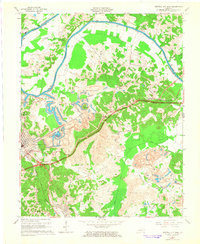
1963 Map of Central City East
USGS Topo · Published 1965About this map
The Green River carves a winding path along the boundary of Muhlenberg and Ohio Counties, anchoring an industrial landscape defined by coal and energy. Extensive Strip Mines dominate the topography east of Central City, where the earth is reshaped into tiered basins and ponds. This 1963 revision documents a critical junction of infrastructure, featuring the Western Kentucky Parkway intersecting with the Illinois Central and Louisville and Nashville railroads. The map captures the social geography of the coalfields through numerous rural churches like Mt Olive Ch and Oakland Ch, alongside small company-linked settlements such as Cleaton, Holt, and Martwick. To the northwest, the Green River Power Plant stands as a focal point of the river-side economy, while established cemeteries like Rose Hill Cem and Fairmount Cem provide valuable touchstones for regional genealogy.
Find a feature on this map
37 named features on this map. Tap any name to fly to it.
Don’t see what you’re looking for? This feature index may not catch every label — zoom into the map to look around manually.
Map Details
Editions of this 1963 Central City East Map
3 editions found
Other maps of this area

1909 · Hartford
USGS Topo · 1:62,500

1909 · Central City
USGS Topo · 1:62,500

1911 · Drakesboro
USGS Topo · 1:48,000

1911 · Dunmor
USGS Topo · 1:48,000

1913 · Drakesboro
USGS Topo · 1:62,500

1914 · Dunmor
USGS Topo · 1:62,500

1952 · Equality
USGS Topo · 1:24,000

1952 · Livermore
USGS Topo · 1:24,000

1952 · Greenville
USGS Topo · 1:24,000

1953 · Drakesboro
USGS Topo · 1:24,000