1950 Map of Central La Plata NO
USGS Topo · Published 1950About this map
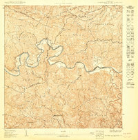
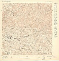
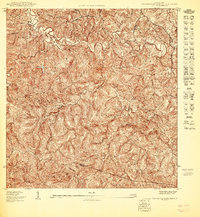
Río Culebrinas winds through this interior landscape of western Puerto Rico, defining a region characterized by intricate topography and dispersed rural settlements. This 1950 edition, produced by the U.S. Geological Survey in cooperation with the Gobierno de Puerto Rico, reveals the dense network of hillside farms and trails across the barrios of Cerro Gordo, Mariani, and Naranjo. The terrain is deeply incised by numerous waterways, including Quebrada Grande, Quebrada Casimba, and Quebrada Palmarinas, which shape the agricultural life of the district. The mapping reflects a period when the inland economy relied heavily on local hydrology and a complex web of footpaths and secondary roads connecting mountain communities like Humatas and Voladoras. This survey provides a precise record of rural life and land use just before more modern infrastructure began to alter these highland corridors.
Find a feature on this map
10 named features on this map. Tap any name to fly to it.
Don’t see what you’re looking for? This feature index may not catch every label — zoom into the map to look around manually.
Map Details
Editions of this 1950 Central La Plata NO Map
This is the sole edition of this map. No revisions or reprints were ever made.
Historical Maps of Sector Los Ramos Through Time
3 maps found