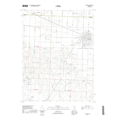
2017 Map of Centralia
USGS Topo · Published 2017About this map
Centralia serves as the primary urban hub on this Central Missouri landscape, where the grid of city streets meets the expansive agricultural reaches of the Audrain and Boone County line. The map highlights a significant network of rural cemeteries, including Glendale Memorial Gardens, Centralia Cem, and Pleasant Grove Cem, which provide essential touchpoints for genealogists tracing family roots in this region. The terrain is defined by a dense drainage system of creeks and branches, most notably Silver Fork, Long Br, and Goodwater Cr, which meander between the small settlements of Larrabee to the north and Hallsville in the south. This era shows a landscape transitioned into a modern road network with numerous local connections such as Dinwiddie School Rd and Angell School Rd, hinting at the historical locations of former rural education centers that once anchored these farming communities.
Find a feature on this map
125 named features on this map. Tap any name to fly to it.
Don’t see what you’re looking for? This feature index may not catch every label — zoom into the map to look around manually.
Map Details
Editions of this 2017 Centralia Map
This is the sole edition of this map. No revisions or reprints were ever made.
Other maps of this area

1890 · Moberly
USGS Topo · 1:125,000

1917 · Sturgeon
USGS Topo · 1:62,500

1945 · Centralia
USGS Topo · 1:62,500

1953 · Moberly
USGS Topo · 1:250,000

1953 · Clark
USGS Topo · 1:24,000

1954 · Moberly
USGS Topo · 1:250,000

1957 · Moberly
USGS Topo · 1:250,000

1958 · Tulip
USGS Topo · 1:24,000

1960 · Moberly
USGS Topo · 1:250,000
1960 · Rowena
USGS Topo · 1:24,000