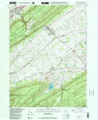
1998 Map of Centre Hall
USGS Topo · Published 1999About this map
Penns Valley is defined by its dramatic alternating ridges and agricultural lowlands, anchored by the borough of Centre Hall and the smaller village of Old Fort. To the northwest, the massive Bald Eagle Mountain and Nittany Mountain dominate the skyline, while the southern reaches are occupied by the densely forested Tussey Mountain within the Bald Eagle State Forest. This landscape illustrates the intersection of rural life and state institutional presence, from the sprawling Rockview State Correctional Institution near Pleasant Gap to the agricultural science of the Pennsylvania State University Agronomy Research Farm.
Find a feature on this map
65 named features on this map. Tap any name to fly to it.
Don’t see what you’re looking for? This feature index may not catch every label — zoom into the map to look around manually.
Map Details
Editions of this 1998 Centre Hall Map
This is the sole edition of this map. No revisions or reprints were ever made.
Other maps of this area

1908 · Bellefonte
USGS Topo · 1:62,500

1909 · Bellefonte
USGS Topo · 1:62,500

1919 · Menno
USGS Topo · 1:62,500

1924 · Centre Hall
USGS Topo · 1:62,500

1924 · Lewistown
USGS Topo · 1:62,500

1927 · Lewisburg
USGS Topo · 1:62,500

1929 · Centre Hall
USGS Topo · 1:62,500

1935 · Allensville
USGS Topo · 1:62,500

1938 · Allensville
USGS Topo · 1:62,500

1943 · Lewistown
USGS Topo · 1:125,000