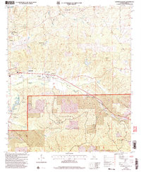
2002 Map of Centreville East
USGS Topo · Published 2003About this map
Talladega National Forest dominates the southern landscape of this Bibb County region, where the terrain transitions from the Cahaba River valley into the wooded uplands of Big Mountain. The town of Centreville sits at a critical junction of local history and modern infrastructure, appearing here with its County Airport, Cahaba Academy, and Ross F Gray Memorial Park. A network of smaller settlements and rural landmarks, such as Vick and Gary Springs, are connected by winding roads and several church-and-cemetery clusters that serve as vital touchstones for family historians.
Find a feature on this map
38 named features on this map. Tap any name to fly to it.
Don’t see what you’re looking for? This feature index may not catch every label — zoom into the map to look around manually.
Map Details
Editions of this 2002 Centreville East Map
This is the sole edition of this map. No revisions or reprints were ever made.
Other maps of this area

1890 · Bessemer
USGS Topo · 1:125,000

1891 · Clanton
USGS Topo · 1:125,000

1892 · Bessemer
USGS Topo · 1:125,000

1899 · Brookwood
USGS Topo · 1:125,000

1910 · Montevallo
USGS Topo · 1:62,500

1934 · Blocton
USGS Topo · 1:48,000

1940 · Blocton
USGS Topo · 1:62,500

1953 · Montgomery
USGS Topo · 1:250,000

1953 · Birmingham
USGS Topo · 1:250,000

1956 · Birmingham
USGS Topo · 1:250,000