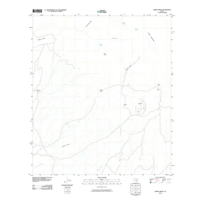
2010 Map of Cerro Orona
USGS Topo · Published 2010About this map
Sullivan Mine, Last Chance Mine, and Ross Mine anchor the eastern slopes of the Chinati Mountains, marking a landscape defined by ranching and mineral extraction. This high-desert terrain is characterized by a series of drainages, including Borracho Arroyo and Las Corrientes Creek, which provide the primary geographical structure for the area. Water management is evident through numerous named collection points such as Cement Tank, Middle Tank, and Back Tank.
Find a feature on this map
18 named features on this map. Tap any name to fly to it.
Don’t see what you’re looking for? This feature index may not catch every label — zoom into the map to look around manually.
Map Details
Editions of this 2010 Cerro Orona Map
This is the sole edition of this map. No revisions or reprints were ever made.
Other maps of this area

1896 · Ruidosa
USGS Topo · 1:125,000

1896 · Shafter
USGS Topo · 1:125,000

1959 · Presidio
USGS Topo · 1:250,000

1965 · Presidio
USGS Topo · 1:250,000

1966 · Adobes
USGS Topo · 1:24,000

1978 · La Boquilla
USGS Topo · 1:24,000

1978 · Sierra Parda
USGS Topo · 1:24,000
1979 · Indio
USGS Topo · 1:24,000
1979 · Chinati Peak
USGS Topo · 1:24,000

1980 · Arroyo Melado
USGS Topo · 1:24,000