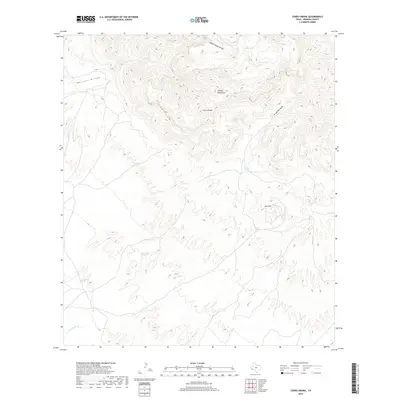
2019 Map of Cerro Orona
USGS Topo · Published 2019About this map
Chinati Mountains dominate the high-elevation landscape of Presidio County, where the topography is defined by significant vertical relief and intermittent water sources. This 2019 survey of the Cerro Orona quadrangle illustrates a network of desert canyons and arroyos, such as Pelillos Arroyo and Arroyo Borracha, that carve through the arid terrain. The presence of named water features like Jesusita Spring, La Cienaga Springs, and Ojo Canoa points to the critical importance of localized springs in this part of the Trans-Pecos. These points of interest, along with man-made catchments like Cement Tank and Back Tank, highlight the infrastructure required for land use in a region where surface water is scarce. From the peak of Red Hill to the lower reaches of Spencer Cr, the map records a wilderness area where ancient geological features and isolated springs dictate the pattern of human and animal activity.
Find a feature on this map
16 named features on this map. Tap any name to fly to it.
Don’t see what you’re looking for? This feature index may not catch every label — zoom into the map to look around manually.
Map Details
Editions of this 2019 Cerro Orona Map
This is the sole edition of this map. No revisions or reprints were ever made.
Other maps of this area

1896 · Ruidosa
USGS Topo · 1:125,000

1896 · Shafter
USGS Topo · 1:125,000

1959 · Presidio
USGS Topo · 1:250,000

1965 · Presidio
USGS Topo · 1:250,000

1966 · Adobes
USGS Topo · 1:24,000

1978 · La Boquilla
USGS Topo · 1:24,000

1978 · Sierra Parda
USGS Topo · 1:24,000
1979 · Indio
USGS Topo · 1:24,000
1979 · Chinati Peak
USGS Topo · 1:24,000

1980 · Arroyo Melado
USGS Topo · 1:24,000